
Snow, Colder Temperatures Return to West, Plains and Midwest as East Remains Relatively Mild Into Mi
- Admin
- Mar 11, 2020
- 3 min read
At a Glance
Colder air will move into parts of the West, Plains and Midwest by later this week.
Snow is also expected in parts of those regions by this weekend.
A divided temperature pattern featuring a colder West and mild East could persist through mid-March.
Snow and colder air will return to parts of the West, Plains and Midwest later this week as a weather pattern which also favors mild temperatures in the East takes hold through mid-March.
Strong high pressure in western Canada will push cold air southward into parts of the Northwest and Northern Plains by late this week.
Moisture from a disturbance pushing out of the Southwest will overlap with that colder air and produce snowfall in parts of the Plains, Midwest and Rockies. At the same time, a disturbance diving southward into the Northwest will produce snowfall in parts of that region.

Friday-Friday Night
Snowfall will begin to develop in parts of the Northwest and Rockies by Friday or Friday night.
An area of snow or a rain-and-snow mix will also increase from the Northern and Central Plains as far east as Iowa, northern Missouri and west-central Illinois.

Saturday-Saturday Night
Snow or a rain-and-snow mix might spread as far east as central Indiana and central Ohio.
There could also be more light snow in parts of the Northern and Central Plains.
In the West, significant snow will develop in California's Sierra Nevada. This could affect travel over the weekend on Interstate 80.

Sunday-Sunday Night
Snow will persist from California's Sierra Nevada to the northern Rockies and Northern Plains as the weekend comes to a close.
There could be more snow next week from parts of the West to the Northern and Central Plains and upper Midwest. But it's too early to provide more details.

How Much Snow?
Snowfall through this weekend will be heaviest in the higher elevations of the West. California's Sierra Nevada will pick up a foot or more of beneficial snowpack. Parts of northern and western Montana could see 6 or more inches of snow.
In the Plains, there will be light to moderate accumulations, especially in central Nebraska.
Lighter snowfall totals are anticipated in portions of the Midwest. There could be a coating to perhaps an inch or two from northern Missouri and southern Iowa into central Illinois and central Indiana.

Divided Temperature Pattern to Persist Through Mid-March
The jet stream pattern through mid-March favors a split between a persistence of relatively mild temperatures in the East and colder air in parts of the West.
The coldest air in this pattern will be confined to near the Canadian border. Highs in Montana this weekend could be up to 30 degrees below average.
Most of the West has the highest odds for below-average temperatures next week.
That's because a general southward plunge of the jet stream is expected to set up and remain in place.
Parts of the East, especially the South, will continue to have the greatest odds for above-average temperatures through mid-March.
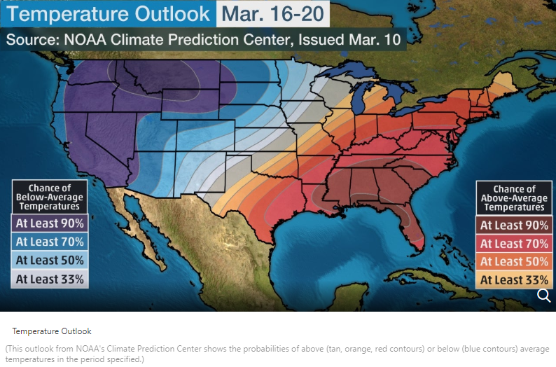
There is already a widespread area of above-average temperatures encompassing much of the South and East through late this week.
Highs in many areas could be 10 or more degrees above average at times.
A cold front will knock temperatures down closer to average in the Midwest, mid-South and Northeast by Friday or this weekend.
But as NOAA's latest 6- to 10-day outlook illustrates above, the general weather pattern will favor warmer-than-average temperatures in parts of the South and East through the week of St. Patrick's Day.


Comments